Please be safe out there!
~YOUR Real Estate Agent, Jessica Garcia Stevens
GEMA/HS Urgent: Winter Storm Expected on Friday 1/10/2025


A significant winter weather event is expected across North and Central Georgia on Friday with impacts lingering into the weekend. A mix of rain, freezing rain, sleet, and snow will begin to move into western Georgia by sunrise on Friday, overspreading much of North and Central Georgia throughout the morning. This wintry mix will continue through Friday afternoon and evening before diminishing early Saturday morning. While exact snow and ice totals are still difficult to pinpoint, the highest amounts and greatest impacts are expected along and north of the I-20 Corridor. However, impacts could be felt as far south as Columbus and Macon, if not much of Central Georgia.
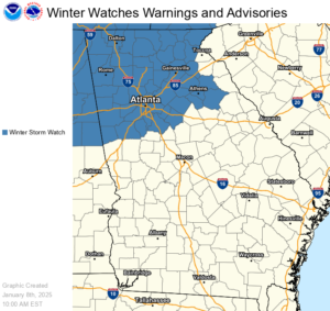
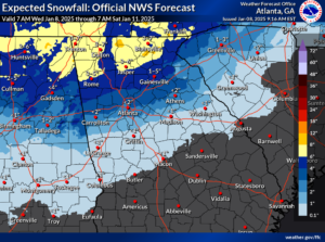
A Winter Storm Watch has been issued for 46 counties in North Georgia for Friday morning through Saturday morning (see attached map). Snowfall accumulations of 2 to 4 inches will be possible in these counties with an additional one-tenth of an inch of ice accumulation. North Georgia mountain counties could receive 3 to 6 inches of snowfall. The Winter Storm Watch will likely be upgraded to a Winter Storm Warning as we approach the event and could be expanded to include more counties. Counties in North and Central Georgia that are not currently in the Winter Storm Watch could still see significant winter weather impacts, and a Winter Weather Advisory may also be issued for areas expected to receive less than two inches of snow or one-tenth of an inch of ice but still enough to cause inconveniences.
All of North and Central Georgia should expect impactful winter weather on Friday. See the attached graphics for expected snow and ice accumulations, as well as worst-case scenario snow and ice totals and best-case scenario snowfall amounts (best-case scenario ice is zero) — keeping in mind that these amounts may fluctuate as the forecast evolves. Temperatures will be near or below freezing between the onset of wintry precipitation Friday morning all the way through sunset on Saturday. A one or two degree shift at the surface or a few thousand feet high will make a huge difference in whether precipitation falls as snow, sleet, freezing rain, or rain.
Travel conditions will begin to deteriorate with the onset of wintry precipitation Friday morning, and roads may remain hazardous through the weekend. With winds increasing on Saturday, any remaining snow and ice could bring trees and powerlines down. Temperatures will drop into the lower 20s on Saturday night across North and Central Georgia, so any remaining moisture will refreeze by Sunday morning. Sunday afternoon temperatures should reach the lower 40s, which should dry things out by Sunday night.
Please continue to monitor the forecast today and tomorrow and take proper precautions before Friday morning. As always, stay tuned to forecast updates from your local National Weather Service office and reliable media outlets.
Will Lanxton
Meteorologist
GEMA/HS


Leave a Reply